

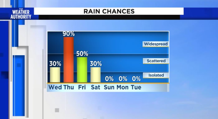
It’s a great day for two wheels and tops down. Rain gear and closed convertibles Wednesday as rain chances increase with widespread, locally heavy, rain expected Thursday and Friday. Saturday will be our transition day as showers come to an end during the afternoon.
Now: Sunny and warm with a nice breeze.
Tonight: Mostly clear skies, patchy fog and not as chilly as the previous nights.
Wednesday: Scattered showers with storms developing during the afternoon, turning to widespread rain late, 40-80 percent. Partly cloudy skies early then becoming cloudy by noon. Rain chances increase through the evening and overnight. Partly cloudy with patchy fog, lows in the 60s to low 70s. Afternoon highs in the 70s to low 80s. Wind NE 10-15 mph. Cloudy with rounds of rain overnight.
Hazards: Locally heavy rainfall and flooding. 2 to 4 inches of rain with higher amounts possible with slightly higher chances of local flooding north of I-10.
Looking ahead: Locally heavy rounds of rain will be possible through Friday. Showers end Saturday followed by a sunny and breezy Sunday
Sunrise: 7:26 am
Sunset: 7:01 pm
Copyright 2023 by WJXT News4JAX – All rights reserved.